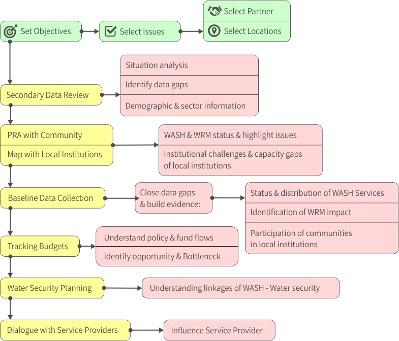
After the data gaps were identified in the secondary data review, additional information about the selected parameters for evidence building was collected through primary level data collection.
Key issues identified in village information sheets
- Status on the functionality of water sources which helped the community identify the focus on additional hardware installation than operation & maintenance of existing infrastructure
- Evidence gaps for the community to have a dialogue with Panchayat members and further negotiate with higher Block administration
- Identified the gaps in the planning process where the community priorities are adequately represented and are consistent with the ground reality
- Need to improve village-level institutions in order to improve service delivery of WASH
Methodology for data collection - Village-level information sheets
Village information sheets were developed by the landscape partners as an outcome of their capacity building. (supported / coordinated by Watershed consortium partners). The information was collated by triangulating findings collected through formal and informal methods of enquiry using the following three tools:
- Problem-tree analysis
- Community Focus Group Discussions
- Participatory Rural Appraisal
(a) About Problem tree analysis
https://www.odi.org/publications/5258-planning-tools-problem-tree-analysis
Problem-tree analysis helped to deconstruct key challenges for WASH and WRM in the villages, the key emerging issues, the causes and the factors that contribute to the issue, interlinkages between factors and how this problem branches out into a set of consequences.
(b) About Focus Group Discussion (FGD)
FGDs were conducted with community members, disadvantaged groups and village leaders to understand the challenges faced in service delivery, track the historical evolution of water resource management, identify the challenges in sanitation The inquiry also focussed on understanding the community’s perception about linkages between WASH-WRM, community-level service provider responsible for maintenance of water sources and sanitation coverage, components of village-level water security and sanitation plans, actions taken by village-level institutions towards fulfilments of these plans and leveraging of government schemes towards these plans.
(c) About Participatory Rural Appraisal (PRA)
https://en.wikipedia.org/wiki/Participatory_rural_appraisal
During the PRA exercise the entire community traversed their villages to note the status of their WASH infrastructure and translate the information into hand drawn maps which formed the basis of discussions. The community used their observations to understand and assess existing status of WASH services and identify the possible WRM gaps. The joint exercise resulted in hand-drawn village-level resource and social maps i.e. various water and sanitation infrastructure resources, their functional status and distribution across the village in terms of served and unserved populations.It was a good opportunity to involve relevant stakeholders to initiate a discussion on the process of participative planning for village resources.
Village information sheets
| PRA- Ganjam District-Odisha | |
| Village name | Link |
| Kanamana | Resource maps prepared during PRA exercise: Content awaited from WISA |
| Arjapalli | 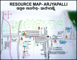 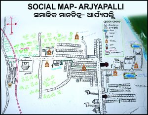 |
| Podapaddar | Resource maps prepared during PRA exercise: Content awaited from WISA |
| Augustinugaon | 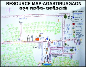 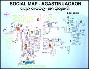 |
| PRA- Samastipur District, Bihar | |
| Village name | Link |
| Barbatta | Resource maps prepared during PRA exercise: Content awaited from WISA |
| Rupauli Buzurg | Resource maps prepared during PRA exercise: Content awaited from WISA |
| Lakhanipur Maheshpatti | Resource maps prepared during PRA exercise: Content awaited from WISA |
| Raipur | Resource maps prepared during PRA exercise: Content awaited from WISA |
| Bhagwanpur Kamla | Resource maps prepared during PRA exercise: Content awaited from WISA |
| Village Information Sheets- Ganjam District-Odisha | |
| Village name | Link |
| Kanamana | village-information-takiria-behrampur |
| Arjapalli | village-information-sana-arjapalli |
| Podapaddar | village-information-sheet-humari |
| Augustinugaon | village-information-agasti-nuagan |
| Village Information Sheets- Samastipur District, Bihar | |
| Village name | Link |
| Barbatta | Content awaited from WISA |
| Rupauli Buzurg | Content awaited from WISA |
| Lakhainipur Maheshpatti | Content awaited from WISA |
| Raipur | Content awaited from WISA |
| Bhagwanpur Kamla | Content awaited from WISA |
Purpose of the baseline survey
In 2017, a Baseline survey about the status of WASH and WRM services in the landscape villages was conducted to understand the existing situation and assist the community to prepare evidence for advocacy for improved services. The baseline survey helped to:
- Validate / support the issues / facts already known to the community and ratified during the PRA exercise
- Generate real-time status and distribution of WASH services and infrastructure in the villages
- Highlight the impact of WASH infrastructure and services on WRM thereby ascertaining the linkages between WASH-WRM.
- Promote greater accountability and ownership of community representatives by involving them in data collection and set the stage for dialogue for advocacy.
Key issues identified in the baseline mapping survey:
- For the first time, Community was informed of the national standards of “functionality” of water points. It is a combination of coverage, safety, adequacy and reliability of water points. Insights from data informed the community to track their water sources on all the above components and realised the need to sustain the existing water sources than installation more water points
- In the water point mapping survey, each public water source was tested on four water quality parameters; Iron, coliform, pH and Electrical Conductivity (Salinity). Water source was classified as safe if it conformed to the permissible limit as per the national standards
- Close to half the water sources were identified as unsafe. It helped clear the community's perception about improved water sources such as handpumps /tap-water providing safe water
- It also convinced the community and its leaders of the need for regular water testing as a priority in the village plan
Methodology and Location for baseline survey
In Odisha, the survey was conducted in 10 revenue villages (6,905 households) in 4 Gram Panchayats and in Bihar the survey was conducted 10 revenue villages (11,937 households) in 5 Gram Panchayats. The baseline survey had two components i.e. Household survey and Water point survey
The Household survey was a sample survey. Using systematic random sampling method, 364 households in Odisha and 406 households in Bihar were surveyed. In addition to demographic profile and access to WASH services, the survey also enquired into hygiene behaviour patterns and the family’s participation in village level institutions and government programmes
The Water point survey was a census survey of all public waterpoints. The survey was designed to gather information about the SDG /JMP indicators and included key WASH parameters i.e. status of WASH services and an understanding of WASH-WRM linkages. This survey was a 100 % mapping of all public drinking water sources in the project sites Each surveyed water point was given a unique number based on administrative codes assigned by the Government of India to make this data comparable to existing government records, type and status of water source. Key information collected during the mapping survey included Water point access, quantity, quality, reliability and WRM related indicators.
A total of 489 water points In Odisha and 1011 water points in Bihar were surveyed.
Who conducted the survey
A group of community youth and representatives from Watershed landscape partners, conducted the surveys. Enumerators were trained on the data collection tools, field methodology and using apps, Akvo Flow and Akvo Caddisfly, for data collection and water quality testing in the field.
Survey Design / methodology and field briefing note
10.2-field-methodology-for-household-and-water-point-survey
Survey tools / questionnaires
Odisha questionnaire
baseline-water-point-survey-form-odisha-monitoring-2017
baseline-water-point-survey-registration-odisha
Bihar questionnaire
baseline-water-point-survey-form-bihar-monitoring-2017
baseline-water-point-survey-registration-bihar
Data sets of the baseline mapping survey
Odisha Data Sets
data_analysis-38270074-household(1)
Bihar Data Sets
data_analysis-32460001_household(1)
Analysis and findings of baseline mapping survey
Analysis plan: Data on WASH -WRM status and service delivery was analysed and presented in easy to understand color-coded charts and maps for dissemination and dialogue between community and duty-bearers .
These insights supported interactions with the community and local government representatives (Gram Panchayat-GP) members to collectively develop an understanding of their WASH-WRM situation and initiate a dialogue to specific priorities to be identified for each village.
| Village-level Dashboards - Ganjam District-Odisha | |
| Gram Panchayat | Village Data |
| Kanamana Village | https://watershedsouthasia.akvolumen.org/s/H6bx-tNnPJA
https://watershedsouthasia.akvolumen.org/s/id_3sE81Ga4 https://watershedsouthasia.akvolumen.org/s/JByyxxqUZzs https://watershedsouthasia.akvolumen.org/s/ePDDg0qknak |
| Arjapali Village | https://watershedsouthasia.akvolumen.org/s/-mpYLD4aW90 |
| Augustinugaon Village | https://watershedsouthasia.akvolumen.org/s/Rxfuem4GP-Y |
| Village-level Dashboards - Samastipur District, Bihar | |
| Gram Panchayat | Village Data |
| Bhagwanpur Kamla Village | https://watershedsouthasia.akvolumen.org/s/GMteiUdw1AQ
https://watershedsouthasia.akvolumen.org/s/0RQScoOboPs |
| Barbatta Village | https://watershedsouthasia.akvolumen.org/s/HhpsKbnC1eY |
| Raipur Village | https://watershedsouthasia.akvolumen.org/s/uFRA6jf4RPw
https://watershedsouthasia.akvolumen.org/s/cTrBvoSY9iI |
| Lakhainipur Maheshpatti Village | https://watershedsouthasia.akvolumen.org/s/JO0Ap8ZImyI |

